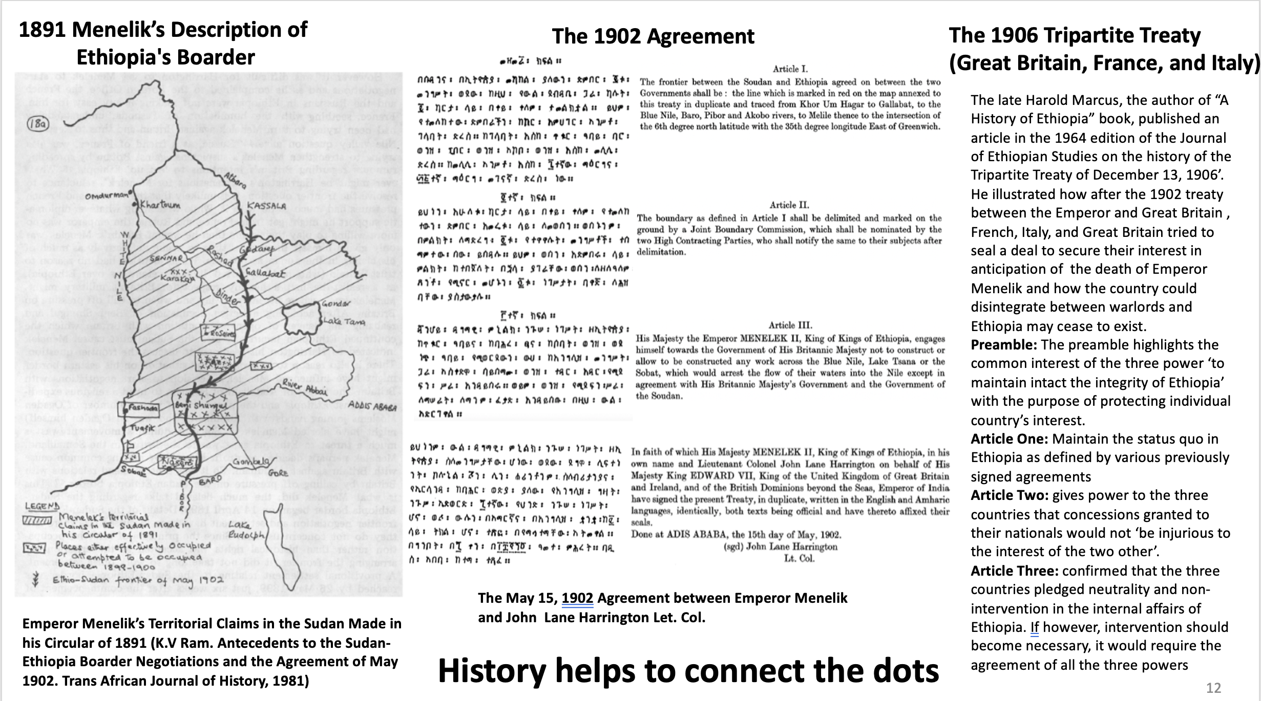
To better understand the 1902 Anglo-Ethiopia treaty, one has to look for events happened a few years before and after the 1902.
The Berlin Conference between 14 European countries that believed to have set the blueprint for dividing Arica ended in 1885. This conference was the formalization of the European scramble for Africa. In 1889, Four years after the Berlin Conference, Emperor Menelik II became Ethiopian king. He learnt the plan for European to divide the continent and felt that he needed to inform them the sovereignty of his country and the boundaries it currently possesses. On April 10, 1891, he wrote a ‘Circular Letter’ to heads of European States (Britain, France, Germany, Italy and Russia). One can see from his letter that he was not happy on the decision to partition and colonize Africa. In the letter he wrote:
‘ Ethiopia has been for fourteen centuries a Christian island in a sea of pagans. If powers at a distance come forward to partition Africa between them, I do not intend to be an indifferent spectator. As the Almighty has protected Ethiopia up to this day, I have confidence He will continue to protect her, and increase her borders in the future. I am certain He will not suffer her to be divided among other Powers’.
The copy of full content of Emperor Menelik’s letter believed to be held in the Public Records Office (London) is added below
Written at Addis Ababa, the 14 th Mazir, 1883 (10 th April, 1891).
(Translated direct from the Amharic.) Addis Ababa, 4 th May, 1897.
Being desirous to make known to our friends the Powers (Sovereigns) of Europe the boundaries of Ethiopia, we have addressed also to you (your Majesty) the present letter.
These are the boundaries of Ethiopia: –
Starting from the Italian boundary of Arafale, which is situated on the sea, the line goes westward over the plain (Meda) of Gegra towards Mahio, Halai, Digsa, and Gura up to Adibaro. From Adibaro to the junction of the Rivers Mareb and Arated. From this point the line runs southward to the junction of the Atbara and Setit Rivers, where is situated the town known as Tomat. From Tomat the frontier embraces the Province of Gederef up to Karkoj on the Blue Nile. From Karkoj the line passes to the junction of the Sobat River with the White Nile. From thence the frontier follows the River Sobat including the country of Arbore, Gallas and reaches Samburu. Towards the east are included within the frontier the country of the Borana Gallas and Arussi country up to the limits of the Somalis, including also the Province of Ogaden .To the northward the line of the frontier includes the Habar Awal, the Gadabursi, and Essa Somalis , and reaches Ambos. Leaving Ambos the line includes Lake Assal, the province of our ancient vassal Mohamed Anfari, skirts the coast of the sea, and rejoins Arafale
While tracing today the actual boundaries of my Empire, I shall endeavour, if God gives me life and strength, to re-establish the ancient frontiers (tributaries) of Ethiopia up to Khartoum, and as Lake Nyanza..
Ethiopia has been for fourteen centuries a Christian island in a sea of pagans. If powers at a distance come forward to partition Africa between them, I do not intend to be an indifferent spectator. As the Almighty has protected Ethiopia up to this day, I have confidence He will continue to protect her, and increase her borders in the future . I am certain He will not suffer her to be divided among other Powers. Formerly the boundary of Ethiopia was the sea. Having lacked strength sufficient, and having received no help from Christian Powers, our frontier on the sea coast fell into the power of the Muslim-man. At present we do not intend to regain our sea frontier by force, but we trust that the Christian Power, guided by our Saviour, will restore to us our sea-coast line, at any rate, certain points on the coast .
This letter was addressed to Britain, France, Germany, Italy and Russia
Public Records Office (London), Foreign Office 1/32 Rodd to Sallisbury, No. 15, 4 th May.

